TEL: 07979 812392
Earthworks Volumetric Analysis
The analysis of material volumes can play a critical part in a project’s
design, the control and monitoring of site operations and after the
project’s completion.
The volumetric analysis of survey data can be used in a variety of ways.
3D Digital Terrain Models (DTMs) are created from which the analysis is carried out.
This is usually a comparison between the original ground level survey and the proposed new levels.
Examples of Volumetric Analyses carried out
Click the links below to view or download drawing pdfs
- Designing proposed sports pitch levels to balance cut/fill earthworks.
- Calculating quarry / borrowpit materials excavated using before and after surveys.
- Producing projected quarry excavation targets for planning permission.
- Calculation expected bulk excavation quantities for developments using initial Topographical survey data and proposed finish levels data.
- Calculating material stockpile quantities.
- Ash Lagoon volume quantities analysis.
- Pre tender analysis to calculate exact material quantities for pricing works.
- Post Contract assistance with Final Measured Quantities based on survey data.
Presentation of Volumetric Data
- Tabulated volume data showing cut/fill/balance volumes, areas and average depths.
- Isopachyte plans showing contoured excavation or fill depths.
- Colour rendered surface intersected DTMs.
- Data can be split between pre defined areas as required
- Cross sections through single or multiple 3d profiles.
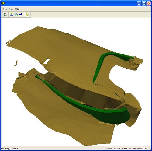
The example below details an exercise to design a road layout and calculate the cut and fill earthworks quantities.
A full topographical survey is carried out on site

the proposed roadline is superimposed onto the survey, taken directly from the relevant architects drawing.

Taking account of maximum allowable road gradients, crossfall or camber requirements and existing site levels, proposed finished levels are added to the road layout, and a DTM is created. This is shown also battered up or down to the original ground levels.

Cut and fill volumes are calculated and tabulated, giving the client valuable pricing/tendering information.

Rendered 3D view of the proposed final shape showing original and proposed profiles.Area of proposed cut and fill can be visualised.